The African continent is currently undergoing massive geological changes. Before delving into the details of these changes, let’s understand some background information about Africa. It is the second largest continent on Earth, covering approximately 30.2 million square kilometers, with 54 recognized countries, making it the only continent with such a high number of countries. The Sahara Desert, located in Northern Africa, is the largest hot desert in the world, covering an area of approximately 3.6 million square miles. Additionally, the Nile River, which flows through Egypt and several other African countries, is the longest river in the world with a length of about 6650 kilometers. Africa is home to the largest land mammal, the African elephant, and the fastest land mammal, the cheetah. Mount Kilimanjaro, located in Tanzania, is the highest mountain in Africa and the highest freestanding mountain in the world, with a height of 5895 meters. The Great Rift Valley, located in Eastern Africa, which runs through several African countries, is the largest geological formation on Earth and is home to many unique plant and animal species.
Africa also boasts a rich cultural heritage, with over 3000 distinct ethnic groups and more than 2000 languages spoken. The continent has a rapidly growing population of over 1.2 billion people, making it the second most populous continent after Asia. Additionally, Africa is blessed with many natural resources, including oil, gas, diamonds, and gold.
Process of Rifting and its History
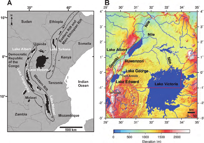
Africa is splitting near the Eastern side, from the Red Sea in the north to Zimbabwe in the South, with a total length of around 6000 kilometers. This region is called the Eastern African Rift, which is an active Continental Rift Zone. As you can see from the map, there are many water bodies in this region, which are all lakes. Natural lake basins are formed when there is a depression in the land that gets filled with water. This land depression can occur due to many reasons, such as the flowing of a river, the moving of glaciers, or volcanic eruptions. Another way that lakes are formed is through tectonic activity. Whenever there is any movement in the Earth’s crust, earthquakes and landslides occur, causing soil displacement and creating land depression where water accumulates. Thus, tectonic activity is also a significant reason behind the formation of natural lakes.
This splitting process will take millions of years to complete and will eventually separate present-day Somalia and parts of Kenya, Ethiopia, and Tanzania from the rest of the continent. This radical change in Earth’s landscape will have numerous consequences, both positive and disruptive, and only time will tell if humans will witness these major changes. Today, let’s explore what the world will look like millions of years into the future after the great rift has taken place.
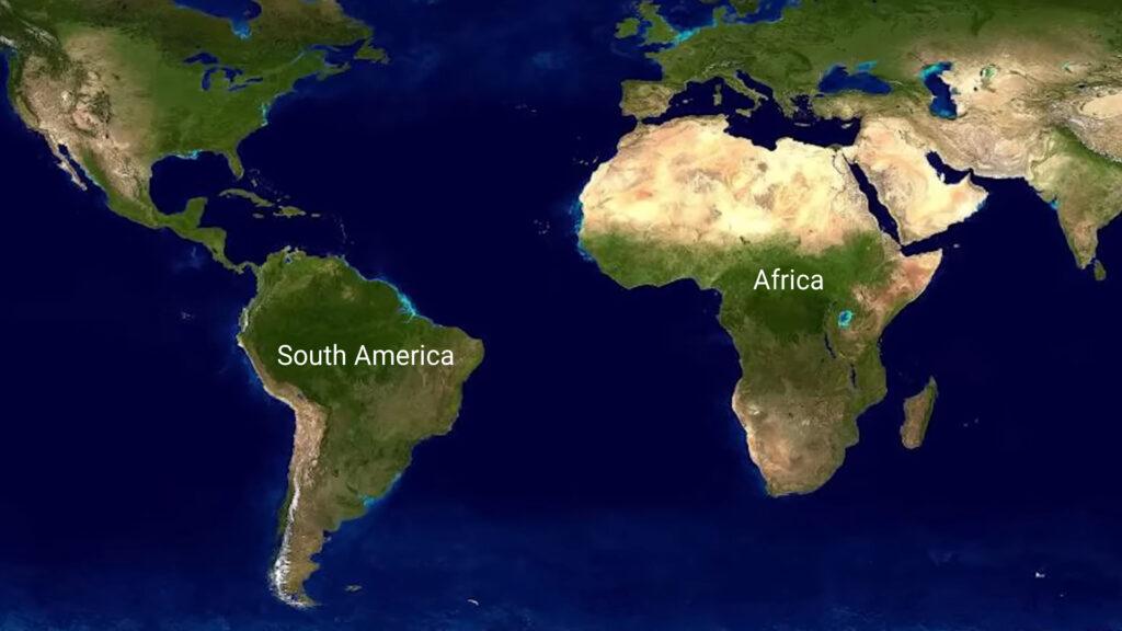
The phenomenon responsible for tearing apart the continent is called rifting, it is when a single tectonic plate rips apart into two or more tectonic plates separated by divergent plate boundaries. This phenomenon can be dated back at least 138 million years, when South America and Africa were divided into different continents. If you look at the west coast of Africa and the east coast of South America, you’ll notice they fit together like two jigsaw pieces, highlighting how these continents were once joined as one.
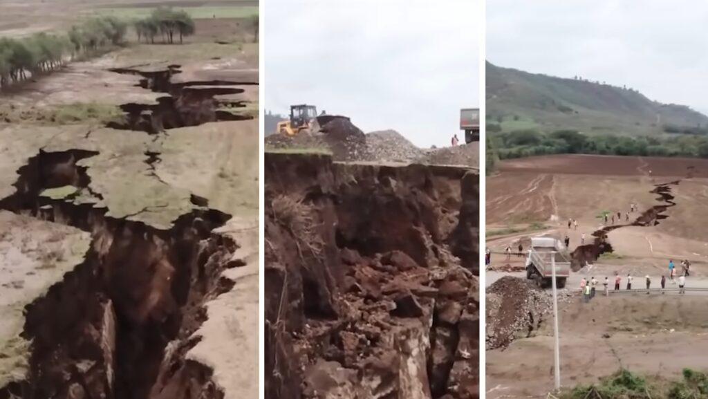
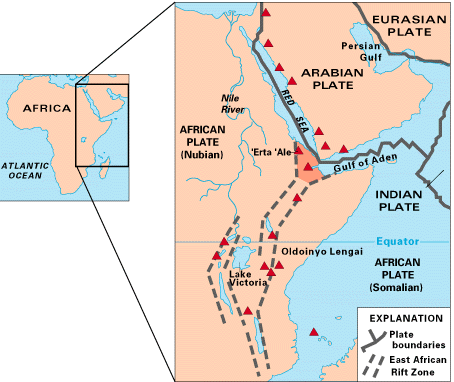
For the last 30 million years, the Arabian plate has been drifting away from Africa, resulting in the creation of the Red Sea and the Gulf of Aden. The colossal breakup of the future is associated with the East African Rift system, a 56-kilometer or 35-mile-long crack that emerged in Ethiopia’s desert in 2005.
It is one of the largest rifts in the world that stretches downward for thousands of kilometers through several African countries, including Ethiopia, Kenya, the Democratic Republic of Congo, Uganda, Rwanda, Burundi, Zambia, Tanzania, Malawi, and Mozambique. This rift will set off the formation of the world’s sixth ocean. Seismic data shows that the formation of the rift was triggered by similar tectonic processes that are taking place at the bottom of the ocean.
The Potential Split: Effects on African Continent and Landlocked Countries
The crack was discovered at the border of three tectonic plates: African Nubian, African Somali, and Arabian, which have already been separating for some time. Spanning over 3,000 kilometers, the East African Rift Valley lies from the Gulf of Aden in the north towards Zimbabwe in the south. It divides the African plate into two parts, the Somali and Nubian plates.
Although the process of rifting has been happening for some time, the potential split made the headlines worldwide for the first time when a large crack in the canyon Rift Valley emerged in 2018. According to scientists, the great split will not happen anytime soon as the Arabian plate is shifting away from Africa at a rate of one inch per year. It will take millions of years for Africa to be sliced into two unequal parts.
The new ocean will take at least 5 to 10 million years to form, which could eventually provide some landlocked countries in Africa with their own coastlines. Assuming that millions of years down the line, nation-states will still exist in their current form. Here’s what we can expect to happen.
Six landlocked countries, namely Rwanda, Uganda, Burundi, the Democratic Republic of Congo, Malawi, and Zambia, would inadvertently find themselves with a coastline if the African continent splits in two. The smaller continent that would emerge from the rift would include present-day Somalia, parts of Kenya, Ethiopia, Eritrea, Djibouti, Tanzania, and Mozambique. However, according to geologists, the smaller continent may drift away from the rest of the continent, leading to the possibility of new nations forming, old nations merging, or completely breaking apart.
Economic advantages of new coastlines for previously landlocked countries
Geologists predict that Madagascar will break apart into smaller islands, and another 5 or 10 million years from now, a new ocean that may arise could be named the African Ocean. And the world will have a new 8th continent. A new coastline in their front yard would cost the country’s millions of dollars in evacuation but it would come with huge advantages. The previously landlocked countries will now have access to the sea, giving rise to the reduction in international logistical expenses and the creation of shipping and fishing industries that did not exist. The countries will build harbors that will connect them to the rest of the world directly. It is to be noted that the Democratic Republic of Congo has a tiny sliver of Atlantic coastline, but it remains in use. Congo, Uganda, Rwanda, and Burundi have largely relied on Kenya’s Indian Ocean port of Mombasa and Tanzania’s port of Dar es Salaam for their sea freight and transportation.
With access to the sea, it also means the countries can finally be directly connected to subsea internet cables if that technology will not have been bypassed by then. Doubtlessly, the emergence of new coastlines will unlock a myriad of opportunities for economic growth. There will be far more maritime activities and a possible shorter route to other parts of the world. But a question lingers: whether this is an advantage for Africa or if it will allow foreigners to take advantage and control the new routes in maritime business.
If we look into the distant future, will the two continents remain connected, or would they split up like North and South America? Would trade bind them together as a single entity, and what would the security implications be? In addition, Africa is the most impacted region when it comes to displacement, with a larger number of countries affected than any other continent or region. As of 2015, more than 15 million people were internally displaced in Africa, according to the United Nations Environment Program report on displacement and environment. As the plates continue to split in the future, this phenomenon will result in the displacement of communities, settlements, and various flora and fauna. These changes will impact their habitats due to climate change, resulting in environmental degradation. Some plant and animal species will become extinct, while others will become endangered due to habitat changes. Finally, rapid urbanization and increased settlements will put pressure on natural resources, leading to a scarcity of water, energy, and food.
Dramatic events such as sudden motorway splitting faults can give continental rifting a sense of urgency. However, rifting is a very slow process that most of the time goes about splitting Africa without anybody even noticing as it happens over the course of millions of years.
In conclusion, the splitting of Africa in two is a natural phenomenon caused by the movement of tectonic plates. While it may bring economic opportunities, it may also cause displacement, environmental degradation, and pressure on natural resources. It is important to discuss the possibilities of the future, even though it may happen over millions of years.


1 Comment. Leave new
[…] Read More – Is Africa Really Splitting into two Continents? […]